Elugelab Island (Site)
Marshall Islands /
Majuro /
Biken /
World
/ Marshall Islands
/ Majuro
/ Biken
World
island, atoll, nuclear testing area, historical layer / disappeared object
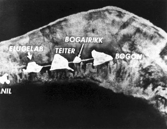
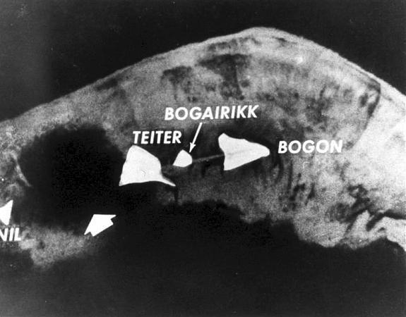
Elugelab was part of the Enewetak Atoll until it was vaporized by the first test of a hydrogen weapon, Ivy Mike.
Wikipedia article: http://en.wikipedia.org/wiki/Elugelab
Nearby cities:
Coordinates: 11°40'2"N 162°11'10"E
- Enewetak Atoll 16 km
- Runit 21 km
- Enewetak 37 km
- Bikini atoll 328 km
- Bikini 364 km
- Rongelap Atoll 483 km
- Rongerik Atoll 564 km
- Wake Island Atoll 974 km
- Wake Island - Wake Island Atoll 974 km
- Peale Island - Wake Island Atoll 975 km
- Ivy Mike crater 0.3 km
- Hardtack 1 Koa shot crater 1.4 km
- Hardtack Oak Crater 12 km
- Deep Entrance 35 km
- Romeo Crater 336 km
- Redwing Tewa crater 344 km
- Castle Union and Yankee craters 351 km
- Operation Crossroads Shots ABLE & BAKER 362 km
- Approximate Position of sunken ships of July 1946 362 km
- Wake Island Airfield (PWAK) 973 km