USA /
Minnesota /
Mendota /

Half-Moon Battery
World / USA / Minnesota / Mendota World / United States / Minnesota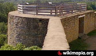
The battery sat 100 feet above the confluence of the Minnesota and Mississippi rivers, offering a spectacular view of the rivers’ valleys and traffic. It may have been the platform for a 24-pounder howitzer listed on an early inventory. To make way for the battery in 1820, builders removed a tree (during Snelling’s absence and against his orders), revealing a bottle containing a copy of Zebulon Pike’s 1805 treaty purchasing the military reservation. By the late 1830s, a suspended walkway connected the battery with the nearby Commanding Officer’s Quarters. Shortly after the Civil War, a conical roof was added to the structure and its use was listed as a bandstand. Like many other of the fort’s buildings, the Half-Moon Battery was demolished around 1879.
www.historicfortsnelling.org/plan-visit/what-do/half-mo...
www.historicfortsnelling.org/plan-visit/what-do/half-mo...
Categories: tower, historical building
Wikipedia article: http://en.wikipedia.org/wiki/Fort_Snelling
Nearby cities:
Coordinates: 44°53'33"N 93°10'45"W
- WCCO Radio Tower 35 km
- Brucemore, A National Trust Historic Site 346 km
- KRDK-TV Mast 417 km
- KFAB-1110 towers 479 km
- KXVO and KPTM tower 492 km
- CIPA-TV Transmitter 1294 km
- Edmonton Institution 1751 km
- Gobblers Knob 2226 km
- Likely Mountain/south Fork Mountain Fire Lookout and Radio Facilities 2256 km
- Sehome Hill Arboretum 2259 km
- Pike Island 1.2 km
- Highland Park neighborhood 1.8 km
- Crosby Farm Park 2.3 km
- Minneapolis St. Paul International Airport Joint Air Reserve Station 2.5 km
- Morris Park Neighborhood 3 km
- Minneapolis-Saint Paul International Airport (MSP/KMSP) 3.4 km
- Gun Club Lake 3.5 km
- Fort Snelling National Cemetery 3.6 km
- Fort Snelling State Park 3.6 km
- Ramsey County 14 km