"Mile-Long/Topside Barracks" Ruins
| military, ghost town
Philippines /
Central Luzon /
Alas-asin /
World
/ Philippines
/ Central Luzon
/ Alas-asin
World / Philippines / Batangas / Alitagtag
military, ruins, ghost town
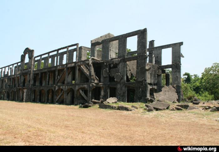
Pre-war massive barracks building designed to house the American garrison of Corregidor. Is designed to be hurricane-proof but demolished by the Japanese aerial and artillery bombardment of 1942.
The start of hostilities forced the garrison to take up residence in the Malinta Tunnel complex.
The start of hostilities forced the garrison to take up residence in the Malinta Tunnel complex.
Wikipedia article: http://en.wikipedia.org/wiki/Corregidor_Island
Nearby cities:
Coordinates: 14°22'53"N 120°34'27"E
- Sangley Point Naval Air Base - Danilo Atienza Air Base (RPLS/SGL) 37 km
- Philippine Army National Headquarters Compound 53 km
- Camp Aguinaldo 58 km
- Lieutenant Cesar Basa Air Base Runway 03/21 69 km
- Lieutenant Cesar Basa Air Base 70 km
- Basa Air Base 70 km
- Lieutenant Colonel Basilio Fernando Air Base 75 km
- Crow Valley Bombing and Gunnery Range 107 km
- Camp Servillano Aquino 119 km
- Fort Magsaysay 130 km
- Corregidor Island (Fort Mills) 1.9 km
- Corregidor Caldera 3.2 km
- GN Dinginin Power Station 6.1 km
- Mariveles Coal-Fired Power Plant 6.4 km
- Cochinos (Pitas) 8.9 km
- The Mariveles Cove 8.9 km
- Mariveles Town Proper 11 km
- Longos Kawayan Point 12 km
- Manila Bay 29 km
- Bataan 37 km