Volcan Parinacota
Peru /
Tacna /
Tarata /
World
/ Peru
/ Tacna
/ Tarata
World / Chile / Tarapacá / Parinacota
mountain, volcano, summit, interesting place
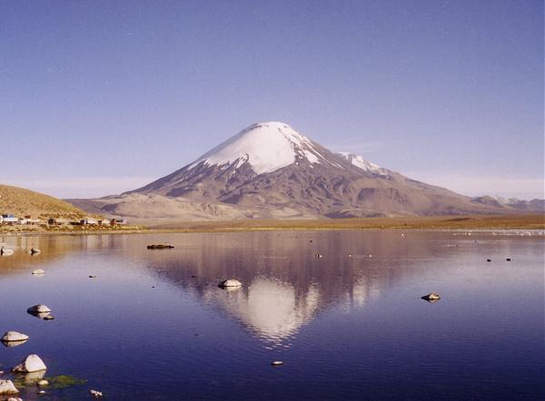
Parinacota is a massive stratovolcano on the border of Chile and Bolivia. It is part of the Nevados de Payachata group of volcanoes. The other major edifice in that group is the Pleistocene peak of Pomerape. Parinacota's last eruptive phase has been dated using the helium surface exposure technique, which ties the eruption to 290AD ± 300 years.
One of the most dramatic eruptive events in the volcano's past was 8000 years ago, when a major collapse of the edifice produced 6km³ debris avalanche. That avalanche blocked drainage patterns in some of the local area, creating Chungará Lake.
Elevation: 6,348 metres (20,827 feet)
Type: Stratovolcano
Last eruption: 290AD ± 300 years
First ascent: 1928
Wikipedia article: http://en.wikipedia.org/wiki/Parinacota_Volcano
Nearby cities:
Coordinates: 18°9'51"S 69°8'33"W
- Khapia Volcano (extinct) 211 km
- Payun Matru Volcano 2022 km
- Cochiquito Volcanic Group 2082 km
- Puyehue-Cordón Caulle 2493 km
- San Salvador (Santiago, James) Island 3110 km
- Pali-Aike Volcanic Field 3750 km
- Volcano Bridgeman 4975 km
- Montagu Island 5658 km
- Volkano Hudson 6517 km
- Mount Takahe 3,460 metres (11,352 feet) 6915 km
- Ajata explosive cones 4.4 km
- Campo Base Parinacota aprox. 4.700 m.s.n.m. 4.7 km
- Chungará Lake 10 km
- albergue 21 km
- Isla Lake 23 km
- Huata Pampa 24 km
- Ingreso al Parque Nacional Sajama 25 km
- Ancuta 32 km
- Domo Tinto 33 km
- Ruins 53 km