Barton High Level Bridge, Manchester Ship Canal (City of Salford)
United Kingdom /
England /
Urmston /
City of Salford
World
/ United Kingdom
/ England
/ Urmston
World / United Kingdom / England
road bridge
Add category
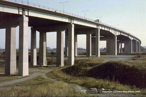
Barton High Level Bridge situated to the east of Barton Locks. Opened in October 1960 as the Stretford - Eccles by-pass it became part of the M63 and serves as part of what has become the western outer ring road for Manchester (now M60).
Barton High Level Bridge is approximately 740 m. (2425 ft.) long and crosses the Ship Canal with an approximately 30.5 m. (100 ft.) clearance over water level. It has a maximum gradient of 1 in 25. It is carried on reinforced concrete piers which vary in height from 9.1 m. (30 ft.) to 24.4 m. (80 ft.) high. There are 18 spans, 13 of 35 m. (115 ft.), two of 41 m. (135 ft.), 2 anchor arm spans to the Ship Canal crossing of 53.3 m. (175 ft.) and the main span of 94.4 m. (310 ft.) which consists of two cantilevers each of 23.6 m. (77.5 ft.) and a 47.2 m. (155 ft.) central suspended span. The superstructure is of riveted steel plate girders 2.75 m. (9 ft.) deep which increase to a depth of 5.5 m. (18 ft.) over the piers for the main Ship Canal crossing. The deck was in the form of a reinforced concrete slab.
Originally built with dual 7.3 m. (24 ft.) two lane carriageways the Barton High Level Bridge quickly became a bottleneck in its own right. It was widened to three lane in each direction and fully opened in this form in 1990. The extra capacity was provided by adding an extra lane to each side of the bridge. The extensions are supported on additional reinforced concrete piers built alongside the original piers.
Nearby cities:
Coordinates: 53°28'9"N 2°22'9"W
- Thelwall Viaduct over Manchester Ship Canal 13 km
- Stockport Viaduct 15 km
- M6 Motorway, Gathurst high level bridge 24 km
- Rakewood Viaduct 25 km
- Mersey Gateway Bridge 26 km
- Silver Jubilee Bridge 28 km
- Victoria Station approach 61 km
- Leeds Inner Ring Road Stage 7. new overpass bridge site 66 km
- Rothwell Motorway Bridge 67 km
- Greyhound Bridge 71 km
- Manchester Sewage Treatment Works 0.6 km
- The Trafford Centre 1.4 km
- Davyhulme Park Golf Club 1.7 km
- Trafford Park Industrial Estate 3.3 km
- Flixton Golf Club 3.4 km
- MediaCityUK 4.6 km
- Salford Quays 5.1 km
- Longford Park 5.7 km
- Sale Moor 5.9 km
- Metropolitan Borough of Trafford 6.6 km