Real
Philippines /
Southern Tagalog /
Pangil /
World
/ Philippines
/ Southern Tagalog
/ Pangil
World / Philippines / Quezon / Real
town, municipality, third-level administrative division
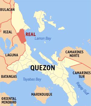
Municipality of Real, Province of Quezon
ZIP code: 4335
Real is a coastal municipality in the province of Quezon in the Philippines. It had a population of 35,189 people as registered in the 2010 Census.
History
Spanish forces landed at the site of Real early in the colonization period, calling it Puerto Real. Spanish galleons and ships docked at the port reinforced forces stationed at the nearby place "Binangonan del Ampon" known now as Infanta.
Formerly a barrio of Infanta, Real was created into a municipal district with a set of government comprising the barrios of Llavac, Cawayan, Capalong, Tignoan, Kiloloron, Lubayat and Pandan which were all segregated from the mothertown of Infanta. This was by the virtue of Executive Order No. 410 dated December 15, 1960 by President Carlos P. Garcia.
Geography
Real is a small town facing the Pacific Ocean, approximately 133 kilometers away from the Quezon capital Lucena City and 145 kilometers from Manila. Real has 17 barangays: 14 rural and 3 urban. Its total land area is 563.8 km², the second largest in the province.
Real has many tourist spots, the zigzag road views, river scenery, Baluti Island and the beaches that attract tourists during summer time.
Real is administratively subdivided into 17 barangays:
-Bagong Silang
-Capalong
-Cawayan
-Kiloloran
-Llavac
-Lubayat
-Malapad
-Maragondon
-Masikap
-Maunlad
-Pandan
-Poblacion I (Barangay 1)
-Poblacion 61 (Barangay 2)
-Tagumpay
-Tanauan
-Tignoan
-Ungos
Wikipedia article: http://en.wikipedia.org/wiki/Real,_Quezon
Nearby cities:
Coordinates: 14°33'11"N 121°33'7"E
- Mauban 13 km
- General Nakar 78 km
- Doña Remedios Trinidad 96 km
- Tagkawayan 99 km
- Labo, Camarines Norte 103 km
- Dipaculao 181 km
- Nagtipunan 203 km
- Dupax del Sur 205 km
- Casiguran 209 km
- Maddela 220 km
- Watershed Tignoan Real, Quezon 6.2 km
- Sitio Little Baguio 6.4 km
- Purok 7 7.3 km
- Sitio Camagong, Magsaysay, Infanta, Quezon 7.4 km
- Sidlakan Adventure 7.8 km
- Rizal 29 km
- Lamon Bay 30 km
- Laguna 36 km
- Laguna de Bay 38 km
- Province of Quezon 67 km