Mira Loma Detention Center/War Eagle Field (site) (Lancaster, California)
USA /
California /
Lancaster /
Lancaster, California /
60th Street West, 45100
World
/ USA
/ California
/ Lancaster
World / United States / California
airport, Second World War 1939-1945, place with historical importance, prison
45100 N. 60th West
Lancaster, CA 93536
Bus. Phone: (661) 949-3811
Inmate Information: (661) 940-3555
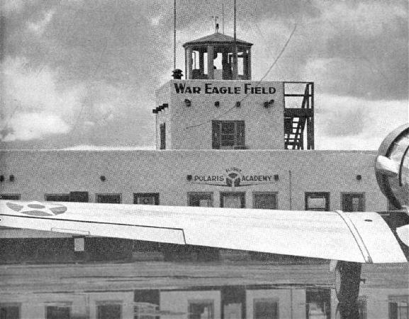
War Eagle Field in Lancaster is not to be confused with another airfield by the same name in Dos Palos, 175 miles to the northwest. War Eagle Field was the site of a contract flying school, Polaris Flight Academy, which was one of four schools operated by the Cal-Aero Flight Academy, headquartered at Glendale's Grand Central Air Terminal. The civilian schools were contracted by the US & foreign militaries to provide flight training for military cadets.
War Eagle Field opened in 1941. It initially provided training to British & Canadian cadets. In 1942, following the United States' entry into the war, it also began the training of USAAF cadets. The War Eagle Flight Academy became at the time the only civilian school in the US to handle basic training of Army pilots.
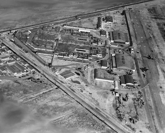
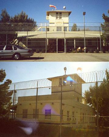
Before its closure around 1964, War Eagle Field became home to a tuberculosis facility in 1954. The facility served inmates until 1979 when it was closed. The facility was re-opened in 1983 and expanded in 1986 to accomadate burgeoning jails, closing in 1993 due to budget cuts and re-openeing in 1997 to house INS detainees.
Many WWII-era buildings are left on the site and still being used by the Mira Loma Detention Center, including the two hangers. The painted words "War Eagle Field" had been faintly visible on top of the hangers up to at least 2003, but they appear to have faded out of existence.
www.airfields-freeman.com/CA/Airfields_CA_PalmdaleS.htm...
www.lasd.org/divisions/custody/miraloma/ml-custodyinfo....
Lancaster, CA 93536
Bus. Phone: (661) 949-3811
Inmate Information: (661) 940-3555
War Eagle Field in Lancaster is not to be confused with another airfield by the same name in Dos Palos, 175 miles to the northwest. War Eagle Field was the site of a contract flying school, Polaris Flight Academy, which was one of four schools operated by the Cal-Aero Flight Academy, headquartered at Glendale's Grand Central Air Terminal. The civilian schools were contracted by the US & foreign militaries to provide flight training for military cadets.
War Eagle Field opened in 1941. It initially provided training to British & Canadian cadets. In 1942, following the United States' entry into the war, it also began the training of USAAF cadets. The War Eagle Flight Academy became at the time the only civilian school in the US to handle basic training of Army pilots.
Before its closure around 1964, War Eagle Field became home to a tuberculosis facility in 1954. The facility served inmates until 1979 when it was closed. The facility was re-opened in 1983 and expanded in 1986 to accomadate burgeoning jails, closing in 1993 due to budget cuts and re-openeing in 1997 to house INS detainees.
Many WWII-era buildings are left on the site and still being used by the Mira Loma Detention Center, including the two hangers. The painted words "War Eagle Field" had been faintly visible on top of the hangers up to at least 2003, but they appear to have faded out of existence.
www.airfields-freeman.com/CA/Airfields_CA_PalmdaleS.htm...
www.lasd.org/divisions/custody/miraloma/ml-custodyinfo....
Nearby cities:
Coordinates: 34°42'2"N 118°13'59"W
- Borrego Valley Manuever Area 224 km
- Camp Essex - Desert Training Center/California-Arizona Maneuver Area (site) 270 km
- Camp Clipper (site) 273 km
- Camp Iron Mountain (site) 288 km
- Camp Granite (site) 290 km
- Poston War Relocation Center 355 km
- Camp Stoneman (site) 497 km
- Skaggs Island 541 km
- Camp Beale (site) 576 km
- Los Alamos National Laboratory 1086 km
- Del Sur 4.4 km
- General William J Fox Airfield (WJF/KWJF) 4.6 km
- Quartz Hill, California 5.5 km
- Antelope Big Sky Solar Field 7.4 km
- Lancaster Highlands 7.8 km
- Antelope Acres, California 8.5 km
- Leona Valley 11 km
- Palmdale Regional Airport/United States Air Force Plant 42 16 km
- San Andreas Fault (Zone) 26 km
- Angeles National Forest 32 km