Regional park Gornje Podunavlje
Serbia and Montenegro /
Vojvodina /
Bezdan /
World
/ Serbia and Montenegro
/ Vojvodina
/ Bezdan
, 13 km from center (Бездан)
World / Serbia / Zapadno-Bački
park, protected area, Ramsar site, forest belt
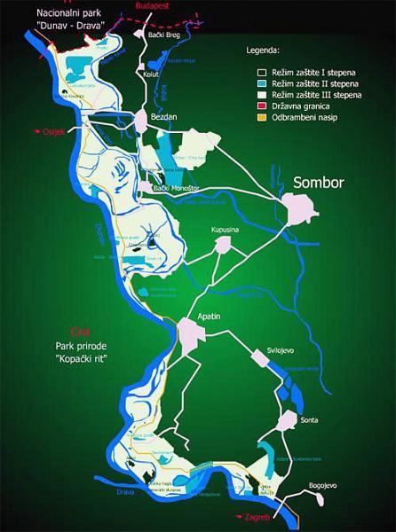
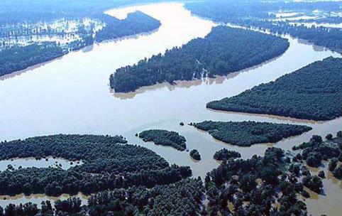
Gornje Podunavlje Special Nature Reserve is a large protected area of wetland in the northwest of Serbia. It comprises two big marshes along the left bank of the Danube River - the Monostor and Apatin marsh, including 66 km (41 miles) of the Danube course (1366 - 1433 km).
The first designation as a protected area dates back to 1955, when an area of 10 square kilometres (3.9 square miles) was proposed as an important habitat for the White-tailed Eagle and the Black Stork. Since then, the area included and the level of protection has been gradually increased. Gornje Podunavlje was designated as a Special Nature Reserve in 2001, with a total size of 19,648 ha (48,551 acres).
Gornje Podunavlje is also an important trans-boundary area, creating a vast Central Danube Floodplains, the large trans-boundary floodplain in the middle Danube, along the route of the southern European Green Belt. It is one of the best preserved wetlands in the Danube River Basin area.
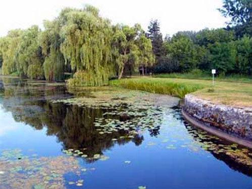
As one of the last integral floodplains of the Danube, it contains some of the most valuable wetland habitats and therefore is a sanctuary for many species, which with their lifecycles, is inherently connected to the river. Natural poplar, oak and willow forests and occasionally flooded wet meadows or numerous oxbow lakes and swamps, which were once widespread in the Danube wetlands, are today rare and fragmented habitats.
The first designation as a protected area dates back to 1955, when an area of 10 square kilometres (3.9 square miles) was proposed as an important habitat for the White-tailed Eagle and the Black Stork. Since then, the area included and the level of protection has been gradually increased. Gornje Podunavlje was designated as a Special Nature Reserve in 2001, with a total size of 19,648 ha (48,551 acres).
Gornje Podunavlje is also an important trans-boundary area, creating a vast Central Danube Floodplains, the large trans-boundary floodplain in the middle Danube, along the route of the southern European Green Belt. It is one of the best preserved wetlands in the Danube River Basin area.
As one of the last integral floodplains of the Danube, it contains some of the most valuable wetland habitats and therefore is a sanctuary for many species, which with their lifecycles, is inherently connected to the river. Natural poplar, oak and willow forests and occasionally flooded wet meadows or numerous oxbow lakes and swamps, which were once widespread in the Danube wetlands, are today rare and fragmented habitats.
Wikipedia article: http://en.wikipedia.org/wiki/Gornje_Podunavlje
Nearby cities:
Coordinates: 45°43'32"N 18°57'30"E
- Kozara 13 km
- Nature park Kopacki rit 17 km
- PP Kopački rit 19 km
- Fruška Gora National Park 62 km
- Danube-Drava National Park - Gemenc 75 km
- The junipers in Barcs 116 km
- Alkali lakes in Kiskunság - Kiskunság National Park 131 km
- Badacsony (Vulcanic hill, with good wine.) 167 km
- Prosara Mt. 171 km
- Nagyvázsonyi-erdő 184 km
- Municipality of Apatin 10 km
- Municipality of Bilje 12 km
- Municipality of Kneževi Vinogradi 16 km
- Municipality of Sombor 16 km
- Municipality of Draž 20 km
- Municipality of Čeminac 21 km
- Municipality of Erdut 22 km
- Municipality of Darda 24 km
- Municipality of Osijek 30 km
- Municipality of Jagodnjak 33 km