Dalworth Airport (site) (Grand Prairie, Texas)
USA /
Texas /
Grand Prairie /
Grand Prairie, Texas
World
/ USA
/ Texas
/ Grand Prairie
World / United States / Texas
historical layer / disappeared object
Add category
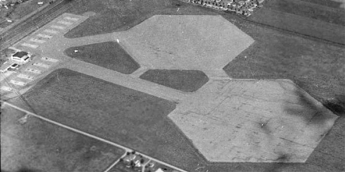
Originally built in 1929, this historic property has been an airfield with at least 6 different names, having gone from a civil airport, to a military airfield, back to a civil airport, and finally as a housing development.
Dalworth Airport / Curtiss-Wright Airport / Grand Prairie Municipal Airport / Grand Prairie NOLF / Grand Prairie Army Airfield
www.airfields-freeman.com/TX/Airfields_TX_Dallas_S.htm#...
Dalworth Airport / Curtiss-Wright Airport / Grand Prairie Municipal Airport / Grand Prairie NOLF / Grand Prairie Army Airfield
www.airfields-freeman.com/TX/Airfields_TX_Dallas_S.htm#...
Nearby cities:
Coordinates: 32°44'6"N 97°1'7"W
- Lion Country Safari (closed) 4.8 km
- Greater Southwest International Airport (GSW) [Closed] 13 km
- Camp Bowie (site) 35 km
- Robertson Park 48 km
- Abandoned Runways 52 km
- MCAS Eagle Mountain Lake 54 km
- The Golf Club at McKinney 61 km
- Gaskin Auxiliary Army Airfield 2 90 km
- Camp Howze WW2 POW Camp 108 km
- Echo Creek Country Club 139 km
- Dalworth 1.5 km
- Northeast Connection 4 km
- Hensley Field 5 km
- Lone Star Park 5.1 km
- Burbank Gardens 5.7 km
- Mountain Creek Lake 5.8 km
- Mountain Creek Lake Park 6.7 km
- Mountain Creek Business Park 7.5 km
- Dallas-Fort Worth National Cemetery 8.2 km
- Dallas County, Texas 23 km
Comments