HMHS Britannic shipwreck
| First World War 1914-1918
Greece /
Attiki /
Laurion /
World
/ Greece
/ Attiki
/ Laurion
, 26 km from center (Λαύριον)
World / Greece / Stereá Elláda
First World War 1914-1918, shipwreck
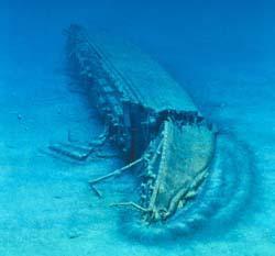
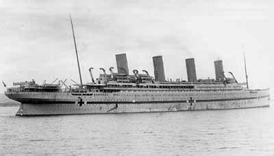
The third ship of the Olympic Class and sister ship to the Titanic, the Britannic was completed as a hospital ship and pressed into WWI service with the British Navy. On her 6th voyage from England to the Mediterranean theatre to evacute the sick & wounded when she struck a mine left by U-73. The ship had a huge hole blown in her bow and began to sink rapidly through damaged watertight doors and open portholes. Through skillful action by her captain and crew, only 30 lives were lost, out of a complement of 1,000.
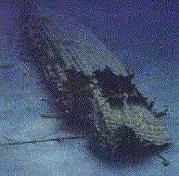
Her wreck was discovered in 1975 by Jacques Cousteau and then again by Robert Ballard, who discovered the Titanic. The ship rests on her starboard side in 350 feet of water and is considered a war grave.
www.youtube.com/watch?v=J9D24j1fliA
Her wreck was discovered in 1975 by Jacques Cousteau and then again by Robert Ballard, who discovered the Titanic. The ship rests on her starboard side in 350 feet of water and is considered a war grave.
www.youtube.com/watch?v=J9D24j1fliA
Wikipedia article: http://en.wikipedia.org/wiki/HMS_Britannic
Nearby cities:
Coordinates: 37°42'4"N 24°17'9"E
- SS Heraklion Shipwreck 93 km
- "Heraklion" shipwreck 132 km
- SMS Breslau / Midilli wreck 305 km
- MS Norman Atlantic incident 524 km
- HMS Barham(wreck) 599 km
- INS Dakar 665 km
- HMS Defender 669 km
- Two Archaeological Sites of Phoenician Shipwrecks 1127 km
- Sinking of HMS Bedouin 1138 km
- SS Thistlegorm(wreck) 1420 km
- H.m.h.s. Britannic
- Kephala 4.3 km
- Agios Nikolaos 8.2 km
- Ancient Piisses 12 km
- Kea (aka Gia) 12 km
- Kato Meria 13 km
- Karthea 16 km
- Loutra bay 32 km
- Kythnos 37 km
- Myrtoan Sea 116 km