Gournadi Upazila HQ
Bangladesh /
Barisal /
Gaurnadi /
World
/ Bangladesh
/ Barisal
/ Gaurnadi
township, subdistrict, fourth-level administrative division, local government
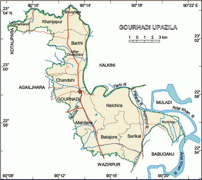

Gournadi Upazila (Barisal district) with an area of 144.14 sq km, is bounded by kalkini upazila on the north, wazirpur upazila on the south, babuganj, muladi and Kalkini upazilas on the east, agailjhara upazila on the west. Main river is Nunda.
The location of Gournadi town is 22.9722186N 90.222728E. Gournadi (Town) consists of 9 wards and 20 mahallas. The area of the town is 12.99 sq km. It has a population of 37411; male 51.31% and female 48.69%. Literacy rate among the town people is 48.8%.
Gournadi thana was turned into an upazila in 1983. It consists of one municipality, 7 union parishads, 122 mouzas and 124 villages.
Archaeological heritage and relics: Single domed ancient mosque, known as Allahr Masjid at Kasba.
As of the 2001 Bangladesh census, Gaurnadi has a population of 180,219. Males constitute are 51.03% of the population, and females 48.97%. Muslim 85%, Hindu 12% and others 3%.
Gaurnadi has an average literacy rate of 59.4% (7+ years).
Literacy and educational institutions: Average literacy 42.1%; male 48% and female 36.2%. Educational institutions: government college 1, non-government college 4, high school 25, government primary school 87, non-government primary school 22, madrasa 213, technical institution 1. Noted educational institutions: Pinglakathi Model Government Primary School (1882), Harisen Government Primary School (1885), Ramsiddhi Bazar Government Primary School (1895) and Barthitara High School (1905).
Religious institutions: Mosque 170, temple 20, church 6.
Cultural organisations: Club 22, public library 1, cinema hall 2, circus party 1, theatre group 2, literary society 1, women's organisation 3, playground 13.
Main occupations: Agriculture 35.74%, agricultural labourer 25.62%, wage labourer 3.37%, commerce 13.93%, service 7.82%, transport 2.54%, industry 1%, weaving 1.59% and others 8.39%.
Land use: Cultivable land 10867.6 hectares; fallow land 1860.56 hectares; single crop 31.5%, double crop 58.5% and treble crop land 10%. Cultivable land under irrigation 86%.
Land control: Among the peasants, 15% are landless, 38% marginal, 32% small, 14% intermediate and 1% are rich; cultivable land per head 0.05 hectare.
Fisheries, dairies and poultries Poultry 92, dairy 12, fishery 30, hatchery 4.
Communication facilities- Roads: pucca 40 km, semi pucca 15 km and mud road 300 km; waterways 19 nautical mile.
Manufactories: Rice mill 50, flour mill 7, ice factory 7, saw mill 12, chira mill 1, press 5.
Cottage industries: Weaving 15, bamboo work 125, goldsmith 35, blacksmith 67, potteries 86, wood work 165, tailoring 237, welding 12, bidi 1.
NGO activities: Operationally important NGOs are brac, asa, caritas, grameen bank, SDO, ccdb.
Health centres: Upazila health complex 1, family planning centre 7, satellite clinic 4.
Nearby cities:
Coordinates: 22°58'14"N 90°13'19"E
- Lohajang Upazila 64 km
- Matlab Upazila (North) Area 69 km
- Keraniganj Upazila 87 km
- Rupganj Upazila 114 km
- Kapashia Upazila 147 km
- Patiya Upazila (পটিয়া) 176 km
- Gafargaon Upazila 177 km
- Banshkhali Upazila (বাঁশখালী উপজেলা) 189 km
- Chandanaish Upazila 193 km
- Dhobaura Upazila 248 km
- Gournadi Catholic Mission 0.1 km
- Torki, Barisal 3.1 km
- Sarder Bari, Badarpur, Gournadi 7.5 km
- Labanya Bhusan Ghosh Dastidar's House 8.7 km
- Hosnabad Bazaar 9 km
- Kalkini Upazila Bazaar 12 km
- Alimabad, Muladi, Barisal 12 km
- Kholifar khal-par 13 km
- Barishal Division 60 km
- Dhaka Division 131 km