Lalpur Upazila HQ
Bangladesh /
Pabna /
Ishurdi /
World
/ Bangladesh
/ Pabna
/ Ishurdi
World / Bangladesh / Rajshahi / Rajshahi / Natore
township, sugar refinery, fourth-level administrative division, local government
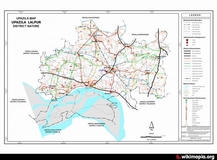
Lalpur Upazila (Natore district) with an area of 327.92 sq km, is bounded by Bagatipara and Baraigram upazilas on the north, Ishwardi, Bheramara and Daulatpur (Kushtia) upazilas on the south, Daulatpur, Bheramara upazilas on the east, Bagha upazila on the west. Main rivers are Ganges, Baral and Khalsadingi.
The location of the Lalpur town is 24.1900335N 88.9781918E. Lalpur (Town) consists of 7 mouzas. It has an area of 8.68 sq km. The town has a population of 15813; male 53.27%, female 46.73%. Literacy rate among the town people is 39.9%. The town has one dakbungalow.
Lalpur thana was established in 1869 and was turned into an upazila in 1983. It consists of 10 union parishads, 214 mouzas and 228 villages.
Archaeological heritage and relics:Mughal Mosque at village Baora.
As of the 1991 Bangladesh census, Population 216973; male 50.71%, female 49.29%; Muslim 94.87%, Hindu 8.73% and others 0.3%; ethnic national: Santal.
Religious institutions: Mosque 256, temple 38, church 2, most noted of which are Bhellabaria Mosque.
Literacy and educational institutions Average literacy 24.2%; male 28.7% and female 19.4%. Educational institutions: government college 1, non-government college 12, high school 35, junior school 6, madrasa 41, government primary school 62, non-government primary school 29, technical institution 1.
Main occupations Agriculture 32.93%, agricultural labourer 32.18%, wage labourer 5.46%, commerce 11.81%, service 6.55%, transport 1.76%, industry 1.2% and others 8.11%.
Land use Total cultivable land 22376 hectares; fallow land 10611 hectares; single crop 38%, double crop 40% and treble crop 22%.
Land control Among the peasants 32.97% are landless, 14.93% marginal, 25.89% small, 18.05% intermediate and 8.16% rich.
Communication facilities Roads: pucca 74.7 km, mud road 330; railways: 24 km.
Manufactories Sugar mill 1, steel work 2.
Cottage industries Weaving 26, goldsmith 28, blacksmith 82, wood work 510, welding 11.
NGO activities Operationally important ngos are brac, asa, grameen bank, Nijera Kari, BRDB, TMC.
Health centres Upazila health complex 1, union health centre 10, maternity 2, public veterinary 5.
Nearby cities:
Coordinates: 24°12'19"N 89°0'3"E
- Sarishabari Upazila 102 km
- Gobindaganj Upazila 116 km
- Bholahat Upazila HQ 117 km
- Shaghatta Upazila 125 km
- Abhaynagar Upazila HQ 132 km
- Fakirhat Upazila HQ 171 km
- Kachua Upazila HQ 191 km
- Koyra Upzila HQ 205 km
- Maidi Vdc 593 km
- Samote Union Council 1827 km
- Iswardi Airport 7.6 km
- Bangladesh Agriculture and Dal Research Center 12 km
- Sugarcane Research & Training Istitute 13 km
- Rayta pathor ghat (bahadurpur) 13 km
- Arkandi 13 km
- Siraj's Bari 15 km
- Rooppur NPP worksite 16 km
- dasuria bazaar 16 km
- Rajshahi Division 113 km
- Khulna Division 149 km