USA /
Massachusetts /
Somerville /
Boston, Massachusetts


Leonard P. Zakim Bunker Hill Memorial Bridge (Boston, Massachusetts)
World / USA / Massachusetts / Somerville World / United States / Massachusetts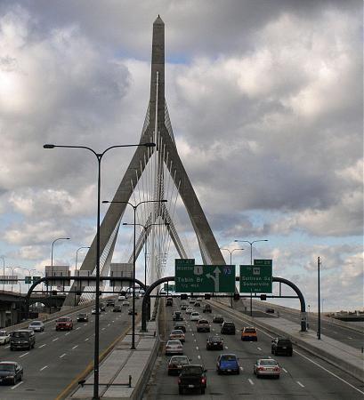
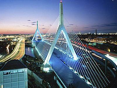
The Leonard P. Zakim Bunker Hill Memorial Bridge carries Interstate 93 and U.S. Route 1 across the Charles River. At a cost of $115,000,000, it was built from 2000 to 2003 as part of the Central Artery/Tunnel Project (the "Big Dig"), replacing the Charlestown High Bridge. The main portion of the bridge is 8 lanes (2x4), and two additional lanes cantilevered outside the cables, which carry northbound traffic from the Sumner Tunnel and North End on-ramp and merge with the main highway north of the bridge. The bridge's name commemorated Leonard P. Zakim and the Battle of Bunker Hill. It has a total length of 1,432 ft (436 m), a width of 183 ft (56 m), a height of 270 ft (82 m), a main span of 745 ft (227 m) and a clearance of 40 ft (12 m) below the deck.
www.leonardpzakimbunkerhillbridge.org/
www.leonardpzakimbunkerhillbridge.org/
bridge
Add category
Wikipedia article: http://en.wikipedia.org/wiki/Leonard_P._Zakim_Bunker_Hill_Memorial_Bridge
Nearby cities:
Coordinates: 42°22'6"N 71°3'46"W
- Maurice J. Tobin Memorial Bridge 2.8 km
- causeway 8.4 km
- Long Island Viaduct (Long Bridge / Long Island Bridge) (Closed) 8.9 km
- Lowell Connector 35 km
- Charles Braga Bridge 74 km
- Mt. Hope Bridge 82 km
- Jamestown Verrazzano Bridge 98 km
- Newport (Claiborne Pell) Bridge 99 km
- Norwottuck Rail Trail 129 km
- Arrigoni Bridge 159 km
- West End (historical) 0.6 km
- NorthPoint 1.1 km
- Bunker Hill Community College 1.1 km
- Charlestown 1.3 km
- Beacon Hill 1.3 km
- East Cambridge 1.4 km
- The Big Dig I-93 Tunnel Section 1.4 km
- Financial District 1.5 km
- Charles River Esplanade Park 1.9 km
- MIT (Neighbourhood) 2.8 km