USA /
Rhode Island /
Providence /
Providence, Rhode Island


Downtown Providence (Providence, Rhode Island)
World / USA / Rhode Island / Providence World / United States / Rhode Island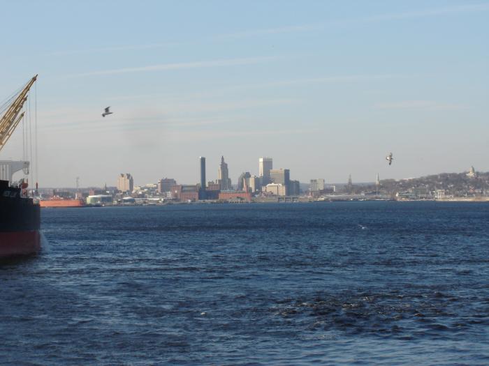
Formerly known as "Weybosset Neck" or the "Weybosset Side" or more recently during the mid-twentieth century as "Downcity," downtown Providence remained largely unsettled until the mid-eighteenth century. The Rev. Joseph Snow, Jr. and his followers, religious dissenters from the First Congregational Society, established downtown's first settlement in 1746 and marked the beginning of approximately 25 years of development where Westminster Street exists today.
By the turn of the 19th century, downtown Providence, along with commercial ventures at the foot of College Hill, was becoming a regional center of commerce and industry. With the British capture and partial destruction of Newport during the Revolutionary War, Providence's harbor was soon the central Rhode Island port. Industrial development in Providence required more advanced commercial and financial services, and by the early 19th century, the downtown area near Turk's Head had become the site of concentrated financial services.
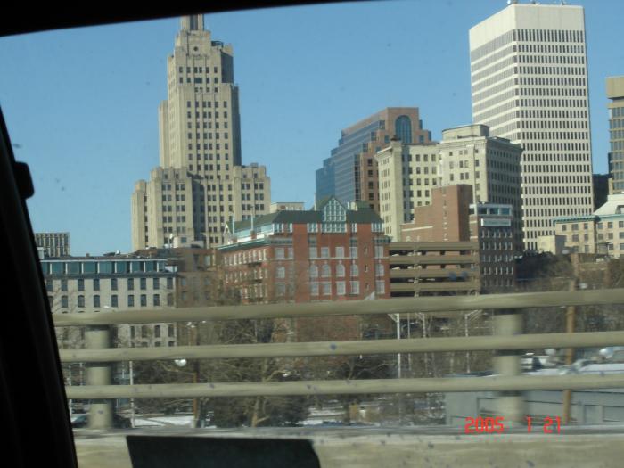
The Turk's Head Building still stands at the confluence of Westminster and Weybosset Streets. The Exchange Bank, Union Bank and Washington Insurance Company were major institutions established during this period. Just west of Turk's Head Place, settlers set about establishing a residential enclave of grand homes in the 1820s. While all but three of these homes have given way to a retail district, several of the churches, including Grace Church, the Cathedral of Saints Peter and Paul, and Beneficent Congregational Church, still exist today.
The period from 1828 to 1928 included dramatic changes in the nature of downtown. Transportation improved dramatically during this time, particularly with the creation of an inter-city rail system. Six railroads converged at downtown's Union Station (1848), increasing the area's importance as a regional economic and transportation hub. Furthermore, by the late 1800s, the Union Railroad Company had established rail service from downtown to outlying sections of the city. Expanding streetcar service caused increased residential construction and the development of a more substantial industrial infrastructure.
Commercial and retail growth, however, continued to occur downtown. By 1860, downtown Providence was a regional banking center with nearly 40 banks and $15 million in capital. The Industrial National Bank (1928) and the Hospital Trust (1919) buildings were two of the many buildings constructed toward the latter part of this period of heavy development. The nation's first enclosed retail mall, the Arcade (1828), was the key development in an active retail district that also eventually included three 19th century department stores which are now gone: the Boston Store, Shepard's and the Outlet Company.
The commercial and retail viability of downtown served as an impetus for the growth of civic, arts and entertainment institutions. The establishment of theaters, churches, hotels, and restaurants occurred rapidly during this century-long era of activity, and included the now demolished Narragansett Hotel (1828), the Biltmore Hotel (1922), and theaters like the Providence Opera House (1871) and Loew's State Theater, known today as the Providence Performing Arts Center. The development of the Providence Public Library in 1900 also served to make downtown the center of civic activity.
After some stagnation, the 1950s saw numerous urban renewal schemes. The Weybosset Hill Redevelopment Project involved the clearance and redevelopment of a blighted area on the western rim of downtown. Further demolition occurred near Turk's Head in order to create more parking. In general, these urban renewal efforts were planned poorly and did little to bolster the image and prosperity of downtown. With the construction of interstates 95 and 195, and Route 10, there was an even greater flight of business, particularly retail, out of downtown. Not until the late 1960s and early 1970s, with the construction of the Providence Civic Center (1972) and the Hospital Trust Tower (1973) did downtown experience a resurgence in growth.
www.providenceri.com/ONS/neighborhoods/downtown
By the turn of the 19th century, downtown Providence, along with commercial ventures at the foot of College Hill, was becoming a regional center of commerce and industry. With the British capture and partial destruction of Newport during the Revolutionary War, Providence's harbor was soon the central Rhode Island port. Industrial development in Providence required more advanced commercial and financial services, and by the early 19th century, the downtown area near Turk's Head had become the site of concentrated financial services.
The Turk's Head Building still stands at the confluence of Westminster and Weybosset Streets. The Exchange Bank, Union Bank and Washington Insurance Company were major institutions established during this period. Just west of Turk's Head Place, settlers set about establishing a residential enclave of grand homes in the 1820s. While all but three of these homes have given way to a retail district, several of the churches, including Grace Church, the Cathedral of Saints Peter and Paul, and Beneficent Congregational Church, still exist today.
The period from 1828 to 1928 included dramatic changes in the nature of downtown. Transportation improved dramatically during this time, particularly with the creation of an inter-city rail system. Six railroads converged at downtown's Union Station (1848), increasing the area's importance as a regional economic and transportation hub. Furthermore, by the late 1800s, the Union Railroad Company had established rail service from downtown to outlying sections of the city. Expanding streetcar service caused increased residential construction and the development of a more substantial industrial infrastructure.
Commercial and retail growth, however, continued to occur downtown. By 1860, downtown Providence was a regional banking center with nearly 40 banks and $15 million in capital. The Industrial National Bank (1928) and the Hospital Trust (1919) buildings were two of the many buildings constructed toward the latter part of this period of heavy development. The nation's first enclosed retail mall, the Arcade (1828), was the key development in an active retail district that also eventually included three 19th century department stores which are now gone: the Boston Store, Shepard's and the Outlet Company.
The commercial and retail viability of downtown served as an impetus for the growth of civic, arts and entertainment institutions. The establishment of theaters, churches, hotels, and restaurants occurred rapidly during this century-long era of activity, and included the now demolished Narragansett Hotel (1828), the Biltmore Hotel (1922), and theaters like the Providence Opera House (1871) and Loew's State Theater, known today as the Providence Performing Arts Center. The development of the Providence Public Library in 1900 also served to make downtown the center of civic activity.
After some stagnation, the 1950s saw numerous urban renewal schemes. The Weybosset Hill Redevelopment Project involved the clearance and redevelopment of a blighted area on the western rim of downtown. Further demolition occurred near Turk's Head in order to create more parking. In general, these urban renewal efforts were planned poorly and did little to bolster the image and prosperity of downtown. With the construction of interstates 95 and 195, and Route 10, there was an even greater flight of business, particularly retail, out of downtown. Not until the late 1960s and early 1970s, with the construction of the Providence Civic Center (1972) and the Hospital Trust Tower (1973) did downtown experience a resurgence in growth.
www.providenceri.com/ONS/neighborhoods/downtown
Categories: downtown / central business district, draw only border
Wikipedia article: http://en.wikipedia.org/wiki/Downtown,_Providence,_Rhode_Island
Nearby cities:
Coordinates: 41°49'22"N 71°24'41"W
- Fort Erie 632 km
- Downtown Columbia 1212 km
- Saint-Pierre 1330 km
- Downtown Jacksonville 1575 km
- Downtown Orlando 1730 km
- Pueblo 2657 km
- Pueblo 2684 km
- Downtown Merida 2881 km
- Dublin City Centre 4871 km
- Santarém 5188 km
- College Hill 1 km
- Upper South Providence 1.3 km
- Smith Hill 1.4 km
- Lower South Providence 2.4 km
- Mount Hope 2.5 km
- West End 2.5 km
- Elmwood 2.7 km
- Elmhurst 3.4 km
- Mount Pleasant 3.8 km
- Silver Lake 3.9 km