Illeginni
Marshall Islands /
Kwajalein /
Ningi /
World
/ Marshall Islands
/ Kwajalein
/ Ningi
World
island, instrumentation
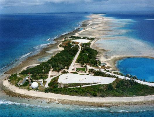
An island on the western fringe of Kwajalein Atoll.
Illiginni was originally built up to host a second launch area for Sprint missiles as part of the Nike-X program, and later the Sentinel and Safeguard developments of Nike-X. Nike-X was designed to be able to use a number of dispersed missile bases so a single attack could not destroy all of the base's missiles. Illiginni's version was one of these secondary sites, with the main site on Meck (to the east) hosting the radars and launch control systems.
Currently the site of the Illeginni PITS (Post Impact Telemetry System) and a fixed camera tower.
www.smdc.army.mil/KWAJ/RangeInst.html
Nearby cities:
Coordinates: 9°5'11"N 167°28'17"E
- Legan 16 km
- Gagan 24 km
- University Science Instrumentation Centre 8142 km
- USAF tower O 11214 km
- USAF tower S 11222 km
- USAF tower K 11233 km
- USAF tower V 11244 km
- USAF L tower 11555 km
- Curtis Instruments, Inc. Headquarters 11655 km
- EST - Empresa Serviços Técnicos, Lda 14584 km
- Kwajalein Atoll 19 km
- Roi Namur 34 km
- Kwajalein 49 km
- Lae Atoll 136 km
- Wreck of HIJMS RO-42 148 km
- Wotho Atoll 199 km
- Wotho Island 201 km
- Rongelap 240 km
- Ailinginae Atoll 258 km
- Rongelap Atoll 259 km