New Zealand /
Northland /
Ahipara /


Ahipara
World / New Zealand / Northland / Ahipara World / New Zealand / Northland / Far North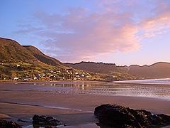
Ahipara is based 14 kms west of Kaitaia, and has a proud history of Maori settlement, gum digging and sea adventures. The name Ahipara means ‘Sacred Fire’ this ancient fire was kept burning constantly for the village, on the ground where the school is now located. Ahipara is in the tribal area of the Te Rarawa people, and descendants of the waka Tinana carried the first people here from the Pacific, landing at Tauroa on the south end of the reef past Shipwreck Bay.
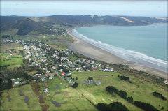
Situated on Ahipara Bay, Ahipara is 18 km north-west of Ahipara Hill, a former gum-digging area and now the site of a historic reserve. The Māori population of Ahipara in the 1950s was reported on (under the name Kōtare) by anthropologist Joan Metge, in A new Māori migration: rural and urban relations in northern New Zealand (1964).
Situated on Ahipara Bay, Ahipara is 18 km north-west of Ahipara Hill, a former gum-digging area and now the site of a historic reserve. The Māori population of Ahipara in the 1950s was reported on (under the name Kōtare) by anthropologist Joan Metge, in A new Māori migration: rural and urban relations in northern New Zealand (1964).
village
Add category
Wikipedia article: https://en.wikipedia.org/wiki/Ahipara
Nearby cities:
Coordinates: 35°10'8"S 173°8'39"E
- Kaeo 55 km
- Hikurangi 112 km
- Kaiwaka 158 km
- Kumeu / Huapai 217 km
- Ngongotaha 422 km
- Bay View 575 km
- Halcombe 589 km
- Havelock North 598 km
- Paraparaumu 655 km
- Opaki 674 km
- Ahipara Bay 1.2 km
- Tauroa Peninsula 5.7 km
- Rangaunu Harbour 28 km
- Taipa Bay-Mangonui 38 km
- Karikari Peninsula 39 km
- Doubtless Bay 40 km
- Ninety Mile Beach 40 km
- Mangonui Harbour 41 km
- Hokianga Harbour 43 km
- Aupouri Peninsula 55 km