Orkhon Valley - UNESCO World Heritage Site
Mongolia /
Ovorhangaj /
Arvajheer /
World
/ Mongolia
/ Ovorhangaj
/ Arvajheer
World / Mongolia / Arhangay
culture, place with historical importance, archaeological site, ancient civilization, UNESCO World Heritage Site
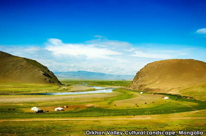

Orkhon Valley Cultural Landscape sprawls along the banks of the Orkhon River, it was inscribed by UNESCO in the World Heritage List as representing evolution of nomadic pastoral traditions spanning more than two millennia.
For many centuries, the Orkhon Valley was viewed as the seat of the imperial power of the steppes. The first evidence comes from a stone stele with runic inscriptions, which was erected in the valley by Bilge Khan, an 8th-century ruler of the Göktürk Empire. Some 25 miles to the north of the stele, in the shadow of the sacred forest-mountain Ötüken, was his Ördü, or nomadic capital. During the Qidan domination of the valley, the stele was reinscribed in three languages, so as to record the deeds of a Qidan potentate.
Mountains were considered sacred in Tengriism as an axis mundi, but Ötüken was especially sacred because the ancestor spirits of the khagans and beys resided here. Moreover, a force called qut was believed to emanate from this mountain, granting the khagan the divine right to rule the Turkic tribes.[1] Whoever controlled this valley was considered heavenly appointed leader of the Turks and could rally the tribes. Thus control of the Orkhon Valley was of the utmost strategic importance for every Turkic state. Historically every Turkic capital (Ördü) was located here for this exact reason. There were many houses by the bank but they are all gone now.
Wikipedia article: http://en.wikipedia.org/wiki/Orkhon_Valley_Cultural_Landscape
Nearby cities:
Coordinates: 47°26'31"N 102°43'42"E
- Uvs Nuur 847 km
- Lake Baikal 938 km
- Daursky State Nature Biosphere Reserve 962 km
- Cửu Trại Câu - JiuZhaiGou Valley National Park 1573 km
- Hubei Shennongjia 1862 km
- Lena Pillars National Park 2167 km
- Sihote-Alinsky Nature Reserve 2509 km
- Manas National Park 2521 km
- Kyoto 3026 km
- Tubbataha Reef Marine Park 4569 km
- Ruin of Khar Balgas 7.6 km
- Qaraqorum 27 km
- Ögii Nuur 37 km
- Confluence of the Orkhan and Tamir Rivers 40 km
- Ika-Togo-Ula 56 km
- Peschanye Dunes El Tarashai 80 km
- abandoned rifle ranges 137 km
- Bulgan Airport 167 km
- The Uran-Togoo Tulga Uul Natural Monument 170 km
- cinder cones 170 km