Harbord Street Bridge (buried 1930) (Toronto, Ontario)
Canada /
Ontario /
Toronto /
Toronto, Ontario /
Harbord Street
World
/ Canada
/ Ontario
/ Toronto
World / United States / New York
bridge, historical layer / disappeared object
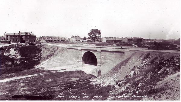
Garrison Creek used to run under this location, the "sunken" parks to the north and south being built in its former course. A concrete road bridge used to span the Creek at this point, and when the Creek was buried they simply filled in under the bridge instead of removing it. All that remains visible is the concrete guard-rail on the northern side of the road.
Nearby cities:
Coordinates: 43°39'35"N 79°25'6"W
- Prince Edward Viaduct 4.5 km
- Overpass 7.1 km
- Burnhamthorpe bridge over Credit River 23 km
- Former Church Street Interchange location 36 km
- Former Harwood Avenue Interchange location 38 km
- Whitby, Port Perry, and Lindsay Railway between North Whitby and Myrtle Jct./Crossing 53 km
- Rainbow Bridge (Ontario - New York border crossing) 69 km
- Wellington & Hwy.6 and 7 70 km
- North Grand Island Bridge 74 km
- Glen Morris Bridge 86 km
- Palmerston-Little Italy
- Bickford Park 0.1 km
- Bickford Park 0.2 km
- Commercial and entertainment area "Little Italy" 0.6 km
- Garrison Creek 0.7 km
- Little Italy 0.8 km
- Harbord Village 1.1 km
- Trinity-Bellwoods 1.4 km
- Little Portugal 1.6 km
- Old Toronto 3.1 km