Laguna Peak Tracking Station
| military, satellite/space tracking station
USA /
California /
Camarillo /
World
/ USA
/ California
/ Camarillo
World / United States / California
military, satellite/space tracking station
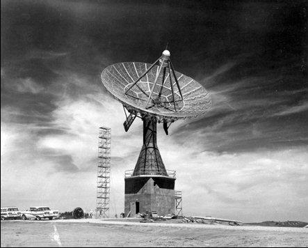
A peak next to the ocean near Ventura that has several aerospace functions. Facilities track and monitor launches of missile from Vandenberg Air Force Base, Point Mugu, and other sites. Laguna Peak's Naval Satellite Operations Station is part of a network of satellite control facilities, headquartered at Point Mugu, CA, that includes stations at Prospect Harbor, ME; Rosemount, MN; and the Lincoln Laboratory in Massachusetts.
ludb.clui.org/ex/i/CA3124/
ludb.clui.org/ex/i/CA3124/
Nearby cities:
Coordinates: 34°6'28"N 119°3'54"W
- Naval Air Station Point Mugu 10 km
- Naval Construction Battalion Center (CBC), Port Hueneme 16 km
- Port Hueneme, California 17 km
- San Nicolas Island 103 km
- San Clemente Island 127 km
- Special Warfare Training Area Three (SWAT-3), SCI Underwater Range 131 km
- Vandenberg Air Force Base (VBG/KVBG) 170 km
- Camp Roberts 258 km
- Naval Air Station Lemoore 268 km
- Fort Hunter Liggett 310 km
- Santa Cruz 3.2 km
- Santa Rosa 3.9 km
- Runway Naval Air Station Point Mugu 3/21 5.4 km
- Sycamore Canyon 5.7 km
- Point Mugu Game Reserve 5.9 km
- California State University, Channel Islands 6.3 km
- Ventura County Game Reserve 6.8 km
- Point Mugu State Park 6.9 km
- University Glen 7 km
- Port Hueneme BMW VPC 11 km
Comments